| Pyramids of Destiny – Lost Pacific Colonies of the Bronze-Age God-Kings |
 |
On Sunday 28th January 2007 Rex and Heather Gilroy carried out an investigation in an area of the Goulburn River National Park, northwest of Mudgee. There is evidence here that the river was once much wider and deeper than it is today, and therefore ideal for the movement back and forth from mining areas in the Mudgee-Gulgong districts.
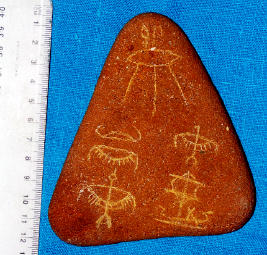
While exploring a bank of the river near a campground, Rex found first one, and then another small inscribed stone. One was engraved on one side with faint weathered Egyptian hieroglyphs. These translated to read “Behold ,beneath Ra’s Eye, the boats loaded with gold, silver and refined copper are sailing upstream”.
|
Pyramids of Destiny – Lost Pacific Colonies of the Bronze-Age God-Kings
by Rex & Heather Gilroy
Copyright
© Rex Gilroy 2009
| “Australian history is almost always picturesque; indeed it is so curious and strange, that it is itself the chiefest novelty the country has to offer, and so it pushes all other novelties into second and third place. It does not read like history but like the most beautiful lies. Mark Twain: Following the Equator [1891] |
”Every truth passes through three stages before it is recognised. In the first, it is ridiculed. In the second, it is opposed. In the third, it is regarded as self evident.” Arthur Schopenhauer [1788-1860] |
Part Four.
Lost Mining Kingdoms of New South Wales.
Chapter Twenty Four.
Horus of Hunter Valley.It is unlikely that the first shiploads of explorers from the Gympie kingdom, who ventured down the east coast would have overlooked the Newcastle region prior to their entry into Broken Bay, for there is growing evidence of a sizeable colony established hereabouts, perhaps following an exploratory voyage inland on the Hunter River which resulted in the discovery of precious metals further inland.
It may also be that, once the Gosford colony was established to become the seat of government of what would become a great kingdom, expeditions were dispatched to explore coastal areas to the north for good mineral deposits, which resulted in the establishment of a mining colony at Taree.
These expeditions would have been dispatched from the Newcastle colony and/or Gosford. The explorers undoubtedly would have ventured deep inland along the Manning River, investigating likely mineral bearing locations, perhaps to find gold far beyond the coast. They certainly found it somewhere deep in the mountains, as we are about to see, from where it was transported down to the coastal settlement which once stood somewhere between the present site of Taree and the nearby Manning River mouth.
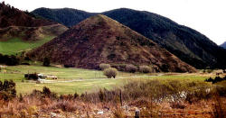
During August 2002 Heather and I visited Taree for a local television interview. While staying here for a couple of days we happened to drive up into the mountain country west of the town. Reaching the densely forested Dingo Tops area of Dingo State Forest, we spent some time searching the scrub.
At one point I climbed up a steep quartz rubble strewn hillside covered in gum forest to reach a flat summitted ridge extending out from a mountainside for some distance westward. Reaching its western end, which I later measured at 37.32m above the dirt track that Heather was parked on waiting for me, I found myself at a crumbling stone walled structure covering a considerable area.
It appeared to be an enclosure constructed out of old mining slag. As I was fully equipped with measuring tape, cameras etc in my backpack, I set about mapping the site, measuring then photographing it. In the midst of the enclosure was a large moss-covered stone, which once cleared of its covering revealed itself to have been an altar stone. The stone was basalt and it had been placed on an north-south axis.
I drew and measured it at 1.26m length by 1.3m width and 65cm height. After photographing it I happened to notice a red slate rock lying half buried in the ground just 60cm out from the altar on its northern side. Removing this rock from the ground I found it to contain a human face carved in relief. Scrubbing off soil from its flat back I discovered familiar Canaanite-Phoenician letterings, reading simply “Baal of the Canaanites”.
I measured the relic. It was 17.5cm in length by 20.5cm in width and had a thickness of 10cm. the face of Baal stared up at me from out of a dim past stretching back 4,000 years. A further 80cm north of the Baal image I afterwards unearthed another partly buried red slate rock, which I found to be engraved upon one side with Canaanite Phoenician script. I measured this rock at 33cm long by 17.5cm wide with a thickness of 12cm.
The inscription stated:
“Temple of the White Sun.
Gather for Baal of the Canaanites”.Here was a message stone which had once been placed in a prominent position where worshippers could see it. Upon closer examination of the altar, I found a small flat area at its northern end where the image of Baal might have once sat. Obviously I was standing in the midst of an ancient temple of Baal. I now carried out measurements of the temple, whose collapsed mining rubble walls formed an enclosure 30m in length by 10.67m in width.
All but the western wall was about a metre tall when intact, the west wall having been composed of very large slabs. The rock employed in the construction of this temple was basalt. Although the west wall had collapsed long ago, I was able to estimate this section of wall to have been up to 2m high.
Through the trees to the east I could see another outcrop of rocks, which I soon measured to be 30.2m distant from the temple. The outcrop proved to be another large man-made structure, built of the red slate and also much quartz ore.
Time was moving on and as it was getting on for late afternoon I knew that I would have to leave measuring this structure until another visit. But from where was the ore obtained? The mass of ancient slag covering the forest floor over a wide area of the ridge had surely been mined somewhere close by. I followed the slag and reef quartz rubble on up the mountain for a short distance to find I was standing in the middle of an ancient road, huge gum trees centuries old grew in its midst to testify that this was no 19th century European mining operation. Ahead of me I could see what appeared to be ancient open-cut diggings in the mountainside.
At this point I definitely had to return to Heather. As I emerged from the trees onto the track carrying the two carved stones, and other rocks picked up along the way, and seeing I had more rocks with which to load the car, resigned to having a rockhound for a husband she said, “You just can’t help yourself, can you!”
Gold and copper are to be found in these mountains I am told, and the mining operations in the vicinity of the temple could not have been all there was to be found yet in this area. More open-cut mining sites must exist, and therefore a miners settlement had also to have been established somewhere hereabouts, now overgrown in these forest depths. Further work by the Gilroys will have to be carried out in this area.
If, as at other major mining operations, oxen drawn carts carried the smelted ores to the nearest waterfront settlement, we theorise that an ancient road had to have been cut up to the Dingo Tops mining site from the Manning River, where the ores were loaded onto vessels for shipment to the coast. Perhaps this road had been opened up from around the present location of Wingham, where a number of Phoenician inscribed rocks have been ploughed up by farmers over the years.
There is plenty of future fieldwork awaiting the Gilroys around Taree, just as there is in the Newcastle-Hunter Districts, as a number of mysterious relics recovered hereabouts over the years suggests. It appears that for centuries before the coming of European settlement, the local Aboriginal tribespeople had preserved traditions which were related to the newcomers in the early 19th century. Among these traditions were beings of stone who had bones growing from their heads.
Similarly, in the Morisset area, half way between Gosford and Newcastle, an ancient rock carving was found many years ago by a bushwalker, depicting a seated human figure with two horns projecting from an animal-like head, surmounted by a circle [Sun Disc]. The “Morisset Deity” as it is known, has been compared with depictions of the Egyptian God Amon of Thebes.
Even in the wake of the revelation of the Old Kingdom period Egyptian hieroglyphic inscriptions near Gosford, university-based historians have, without as much as an inspection of the image, dismissed it as an Aboriginal carving, pointing out that there are many examples of Aboriginal rock art in the Central Coast hinterland, of horned-headed human figures and that the tribesmen who carved them were influenced by cattle introduced by the early European settles of the district. Yet many of these sites date back at least 2,000-3,000 or more years.
Possibly the early Aborigines were influenced to some degree in their artwork by the sight of cattle brought here in the days of the Pharaohs, but what of the “beings of stone”. Had ancient tribespeople seen stone images of Egyptian deities?
Other ancient Aboriginal traditions speak of a “buried city” lying somewhere under the soil of the Hunter Valley.
We do not laugh at such tales and are certain that the Aboriginal people of this region must know a lot more than they are willing to talk about.Evidence of ancient Middle-East presence hereabouts came to light in 1953, when dredge operator, Mr H. Robinson dredged up a large amphora-type jar from 60ft [18-3m] below modern harbour sediments. It was later identified by antiquarians as an ancient Palestinian relic, dating over 3,000 years old.
Main Book Index | Mysterious Australia Homepage | URU Homepage | Australian Yowie Research Centre